Getting Around · 4 min read
Tracking UMich Buses Live: Blue Buses and TheRide
Every bus on campus is a moving dot on this map, with arrival countdowns at each stop. No more guessing where yours went.
Updated 2026-06-10

If you live north and study central, the bus schedule is your real class schedule. MGuide draws every University blue bus and every Ann Arbor TheRide bus on the same live map, so you can watch your bus approach instead of guessing from a timetable.
Following a bus
Turn on transit
Tap the bus icon in the top bar, or go straight to mguide.app/transit. Routes draw on the map in their line colors, with every stop marked.
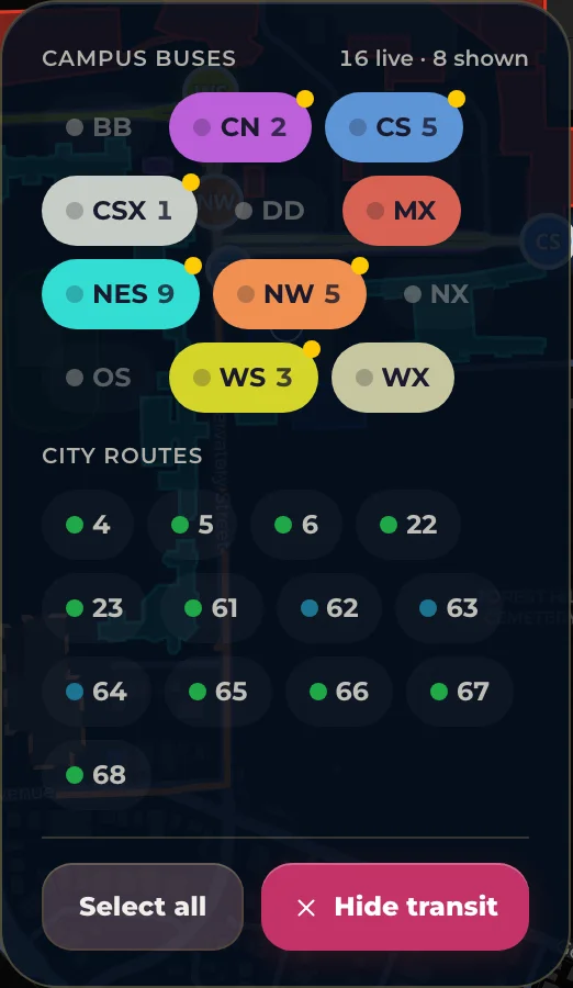
Cut the noise
Tap chips in the route picker to show only the routes you care about. Campus routes like CN (Commuter North) and BB (Bursley Baits) sit on top, TheRide city routes below. 'Select all' brings everything back.
Tap your stop
A stop shows every route serving it and live countdowns for the next arrivals. Late buses are flagged so a '3 min' that's really 10 doesn't burn you.
Route a whole trip
Directions between two points can use the bus: the walk to the stop, the ride, and the walk at the other end, with one combined ETA.
When buses bunch. Two buses stacked on the same route means the first one collects the crowd. Take the second. It's usually half as full and a minute behind.
Blue Bus or TheRide?
University buses are free for everyone, no card needed, and mostly connect the campuses. TheRide covers the rest of Ann Arbor; U-M students, faculty, and staff ride its fixed routes free by showing an MCard, through the MRide program. On this map both systems look the same, so you can take whichever bus is closest instead of the one you happen to know.
Open live bus tracking — Every U-M and TheRide bus on one map
Data sourced from University of Michigan and OpenStreetMap. Last updated July 20, 2026.
Source: mguide.app/guides/ride-the-buses/
Questions or corrections? Contact / Feedback